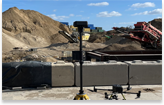
Exciting developments in the UK as AMP8 utility projects kick off, with ProDroneWorx collaborating with top-tier contractors to conduct precise as-build surveys and create BIM models for enhanced project planning and execution.
Project Manager at Tier 1 contractor “ProDroneWorx were engaged to carry out as-build surveys across multiple water treatment (WTW) sites using drone technology. The decision to employ drones over traditional surveying methods delivered significant project benefits in terms of speed, cost-efficiency, and safety. The drone surveys achieved centimetre-level accuracy, with 2D and 3D digital outputs georeferenced to the OS grid. This data was then used by the team to develop BIM models to LOD 200.”
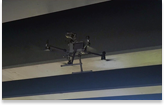
With improvements in drone scanning technology, we are able to capture and model large complex areas in a much smaller timeframe when compared to terrestrial laser scanning. This means that with less time on site collecting the data, we are able to start building the BIM model earlier than with other traditional methods. On the main, models are produced to LOD-200, which provides sufficient detail for space planning or asset capture and management. For areas that require a higher level of LOD we can use terrestrial laser scanners.
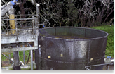
Our client required a 3D model with accurate geo-positioning of all infrastructure across the sites. The model was used to plan for asset locations and undertake both design verification and clash analysis.
The integration of BIM models in WTW projects like these fosters seamless collaboration among stakeholders, unlocking a host of additional benefits such as streamlined communication, real-time design monitoring, enhanced client and public engagement, clash detection, improved safety protocols, cost-effective budget management, and environmentally conscious construction practices.
The power of BIM models shines through in optimising project outcomes and ensuring project success.