Background
As a world leader in green energy and as part of its commitment to achieving net zero emissions by 2050, the UK continues to drive investment and innovation in its offshore wind sector. This includes a target for offshore wind to produce sufficient electricity to power every home in the country by 2030. Well positioned to achieve these goals and remain at the forefront of the next generation of clean energy, the UK currently has the largest installed capacity of offshore wind in the world, with more than 10GW of cumulative installed capacity across 38 sites.
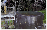
In addition to the planning and building of additional sites, ongoing efforts are also being made to further leverage the energy produced by existing sites and projects. For example, in the case of existing windfarms in the north sea, an additional 60-km-long underground system of cross-country cables will be installed to carry green energy (wind power) from two offshore windfarms to a new onshore substation in the south east of England. From there, the renewable power will be made accessible and distributed to UK homes and businesses.
Our client – an international engineering and construction company – engaged ProDroneWorx to survey a 60km linear route.
Our client said “the LIDAR data captured by ProDroneWorx provided high resolution images & data that was used to develop the FEED design. The data was processed to analyse the scheme topography and determine constructability of the project in specific areas. Overall the quality, accuracy and processing of the data captured fully met our expectations and contributed to the successful delivery of the FEED stage of the project.”
The challenges of designing and planning an underground cable system
While the use of underground power transmission cables offers multiple advantages, their design, planning and installation comes with some challenges, including:
- Need for more extensive excavation work. Before commencing with an excavation in a public space, there is a need to consult and coordinate with many stakeholders to prevent any conflicts and objections prior to construction. These stakeholders include local governmental authorities, environmental authorities, utility companies (electricity, water, gas, communications, etc.), and landowners.
- Need to comply with regulations.
- Run across the country and through multiple ecosystems. This leads to a number of ecological, environmental, technical and infrastructural constraints and a need to optimise the route and minimize disruption to the terrain, existing infrastructure such as roads and railways, and the environment.
- Need to take into account future access to these cables for ongoing maintenance and repairs. This is usually done through the use of carefully planned manhole covers along the length of the underground transition line.
- In order to ensure that these cables continue to operate seamlessly in the future, they are installed within a defined protective easement. No buildings, infrastructure or deep-rooting trees or shrubs can be located in this area after the underground cables are installed.
Overcoming challenges and ensuring accuracy with digital topographical survey, aerial mapping and advanced analytics
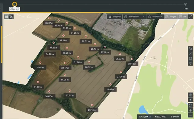
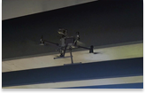
In order to design and plan the project accurately and to ensure minimal disruption to the environment, ProDroneWorx was engaged during the design phase of this project. ProDroneWorx carried out a digital topographical survey of the 60km-long linear route using advanced aerial technology.
Using the latest developments in LiDAR and RTK/PPK aerial technologies, ProDroneWorx carried out a digital topographical survey of the 60km-long linear route and provided survey-grade accurate 2D and 3D digital data outputs tied to the OS grid with global accuracies of approximately 50mm. The aerial survey was completed in one day, as compared with the 50 days it usually takes when using traditional methods using GPS rover or similar to collect this information – leading to time savings of 98% not to mention the health and safety benefits of not putting people at risk in the field
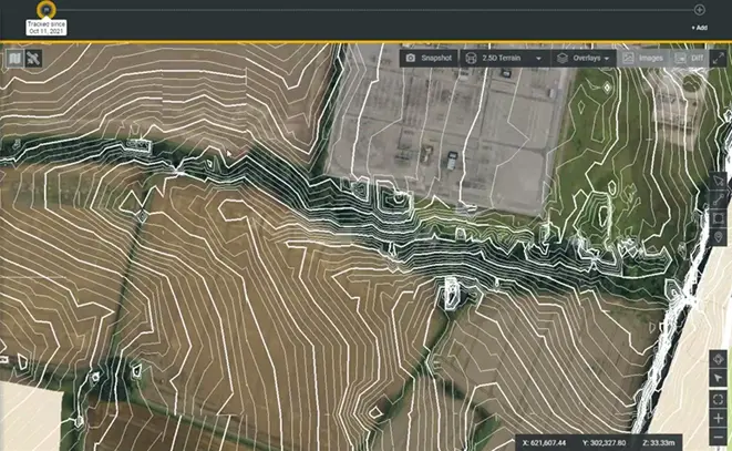
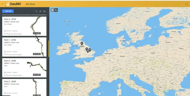
This data was then uploaded to our strategic partners Datumate platform, DatuBIM – this is a cloud-native SaaS 4D infrastructure data analytics platform – analyzed using Artificial Intelligence (AI), and made accessible to all stakeholders involved in the project during the design and planning stages of both the 60-km long underground cable system and the new sub-station.
This digital approach to data capture, analysis, visualisation, and reporting enabled our client to more easily define the construction boundary limits for the planning application during the design phase. Most importantly, it supported far more collaboration by giving multiple stakeholders access to a single source of truth from different locations and time zones. It also facilitated the design of a substation drainage solution by defining accurate contour lines and heat maps.
The following survey grade accurate digital data georeferenced to the OSGB 1936 (OSTN15) was produced for this project:
- 2D Orthomosaic
- 3D Point Cloud
- Digital Terrain Model (DTM)
Main benefits of digital construction management
Companies are moving to a digital design environment as it brings multiple benefits – especially to large, linear projects. These include:
- Better collaboration between stakeholders from different companies, disciplines and locations – cloud-based, single source of truth simplifies and improves the collaboration and decision-making as everything is easily available in one place where multiple stakeholders can review it and make data-based decisions.
- Enhanced safety and time-cost savings – the use of drones and digital construction management technology significantly reduces the need for employees to travel to the physical worksite. This in turn reduces potential risks involved with onsite visits, saves time, and results in cost savings.
- Route optimisation based on accurate data – with access to accurate data from the field, analytics and reports, the route could be optimized in terms of costs and efficiency.
Results
- 80% increase in collaboration
- 98% time-savings vs traditional topographical survey methods
- More than 65% cost-savings vs traditional topographical survey methods
Leading the way to a more renewable future
With renewable energy playing an ever-increasing role in the world’s energy infrastructure, the need for digital construction management from design through to delivery is becoming more and more crucial to the success of such projects. By providing digital visualization tools, a single source of truth, and ongoing reporting, all stakeholders involved in such complex projects – no matter where they are located – can be on the same page and make more accurate and data-based decisions. Both ProDroneWorx and Datumate are proud to play a part in this green revolution!